Features of GeoLab
The latest GeoLab upgrade adds powerful and intuitive new features to previous versions, and as always with such advanced software, improves and corrects some of the older features and existing bugs.
general GeoLab background:
GeoLab has been called the “Cadillac” of surveying and geodetic adjustment software.
Created in 1985 and still being expanded and improved.
Used and trusted world-wide in many countries.
Handles many types of surveying measurements in any configuration - 1D, 2D, 3D, and mixed-dimensional.
GeoLab can do much more than network adjustments. It also performs many related functions including coordinate transformation calculations, map projection computations, and geoid computations.
GeoLab System Requirements
GeoLab requires Windows XP/7/8/10 or later.
overview of GeoLab’s features:
Performs least squares adjustments and simulations (pre-analyses) of geodetic and surveying networks and traverses.
Handles all geodetic and surveying measurements (GPS, GPS RTK, conventional and total-station traversing, both trigonometric and spirit leveling, and even processed inertial surveying data).
There are no software limits on the number of measurements or stations that can be adjusted. GeoLab has successfully adjusted networks with thousands of stations and tens of thousands of measurements.
GeoLab is being used to adjust projects ranging from local traverses to national geodetic control networks.
Used and proven reliable world-wide in all sizes of companies, many government and defense agencies, and many educational institutions.
Coordinate and datum transformations, map projections, and various other utility functions.
Technical support is very responsive, dependable, and professional.
A list of recent additions and changes is shown here, and more features with screenshots are shown below.
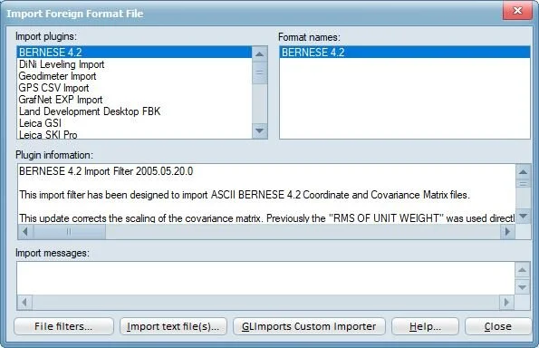
Imports measurement and coordinate data from many types of GPS receivers, total station instruments, and levels.
Available Import Plugins include: Bernese 4.2, DiNi Leveling, Geodimeter, GPS CSV, GrafNet EXP, Land Development Desktop Fieldbook (.fbk), Google KML, Leica GSI, Leica SKI Pro, MANOR, Microsearch Point Coordinate, NGS Bluebook, NGS Datasheet, Nikon Filter, SDR Import Filter, SINEX (.snx), SMI RAW, TDS, TRA, and Trimble Geomatics Office Data Exchange Format 1.0

NEW custom import tool, GLImports, allows users to specify their own import format, allowing for nearly any processed external data to be imported into GeoLab. For more information on GLImports, click here.

GeoLab's Adjustment Results Summary feature makes it easy to locate large residuals and station confidence regions in your adjustment.
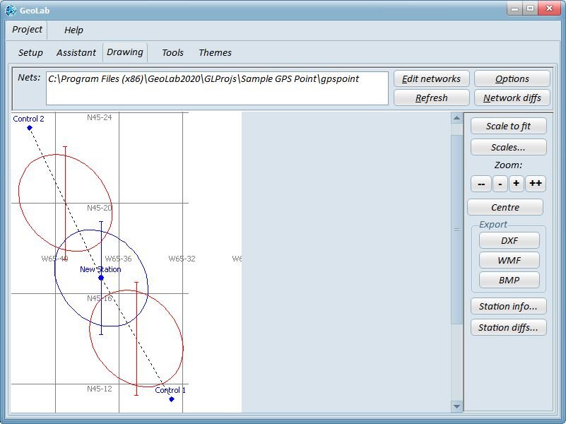
The Drawing tab produces quick and easy visualizations of every aspect of a network, including horizontal error ellipses, vertical error bars, and station and relative confidence regions.

The Themes tab allows for quick changing of the overall color scheme of GeoLab, from a wide variety of options.
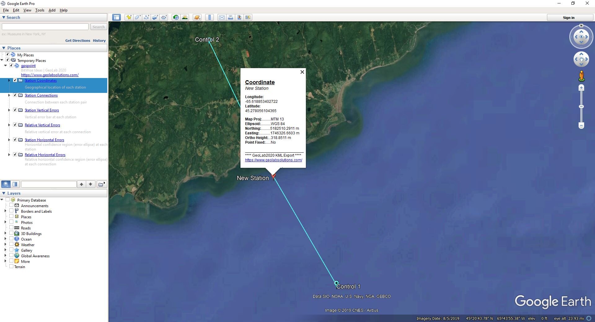
The KML Exports tool produces detailed shapefiles in .kml format for each network, showing all the same statistical values as the drawing tab with their true scale. See more about the KMLExports tool here.
GeoLab is extremely configurable and versatile, making it useful for a wide variety of project types.

Built-in data editing tools make data entry and editing easy.

GeoLab provides powerful tools for incorporating geoids into your adjustments and simulations.

GeoLab's Drawing tab overlay network capability helps with deformation and control closure analyses.

GeoLab also provides a powerful tool for easily renaming stations in an adjustment from "field names" to actual station names.

GeoLab's powerful Coordinate Transformer performs many different types of coordinate transformations.

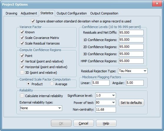
Internal and External reliability statistical testing is available for each observation residual value, providing insight into the weakest observations and coordinate estimations in a network based on the impact of statistically undetectable errors. This feature can be used in a network adjustment or simulation.

GeoLab models several types of scale, translation, and constant parameters right in the adjustment or simulation, and it performs and solves for datum transformations.
GeoLab also handles many different linear unit, reference ellipsoid, and map projection definitions, with the capability of creating your own definitions.
Handles heights of instruments and targets, with automatic reduction of measurements to the station markers.
Efficiently computes all residual standard deviations for a more realistic statistical analysis.
Automatic initial coordinate generation.
An intuitive, powerful interface that is very easy to use.
Automatic data validation that will save you time and simplify your work. You will never again have to wonder if your network data is formatted correctly.
The much anticipated Network Builder and Project Assistant that help you build, adjust, and analyze your projects with easy, powerful features.
An expanded, much-improved, searchable help system.
The ability to handle much larger network adjustments with the new built-in capability of handling 64-bit file sizes.
A new licensing system that allows the easy sharing of "floating" licenses and runs over a local network.
The hardware key is gone! It has been replaced by a very friendly licensing system that is fully Internet friendly!
GeoLab can import foreign-format data files directly. Both GNSS and conventional (e.g. total station) data file formats are supported, and third-party developers can develop their own plug-in modules that GeoLab will automatically recognize and load at startup. All loaded formats are displayed in the Assistant's File/Import... menu.
Network drawing efficiency has been increased dramatically (with immediate scrolling response, for example), and you can now export network drawings to bitmap or metafile formats as well as the usual DXF format.
The GeoLab Preferences dialog has been significantly expanded. A new option to specify the execution priority for GeoLab has been added, which can improve processing speed significantly.
GeoLab supports network adjustments in local x, y coordinates (XY records).
GeoLab's Geoid Manager interface has been substantially improved.
GeoLab's Options dialog has been improved, now providing an "Apply" button so you can see the effects of options changes without closing the dialog.
Station reordering is much more efficient now, and results in more efficient processing of large networks.
GeoLab's toolbar is now more configurable, as well as more complete.
Context help is much improved with new Help on the Web feature!
Text tabs and the network drawing have a more complete and useful context menu (right-click pop-up menus).
GeoLab has a new and improved network drawing print-preview feature.
The output of data in the User-Defined Station Data Lister dialog is more configurable now with the addition of a feature to specify numbers of decimal places in the output.
An option was added to the Coordinate Observation Extraction dialog to output XYZ records and the corresponding covariance matrix in the CT system.